

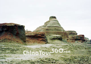
 Urho Devil City, Karamay
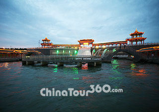 Night of Karamay City
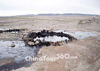 Black Oil Hill Park
![]() Facts
Facts
Phone Code: 0990
Postal Code: 834000
Area: 7,735 square kilometers (2,986.5 square miles)
Population: 290,000 (2010 statistics)
Nationalities: Han, Uigur, Hui, Kazak
Location: Karamay is located in the north of Xinjiang. It borders the Hoboksar Mongol Autonomous County from the north and northeast, the Toli County from the southwest, and Usu and Shawan counties from the south. Karamay is about 313 km (194.5 miles) from Urumqi. Its longitude is between 84°52′E and 86°1′E, while the latitude is between 44°7′N and 46°8′N.
![]() Physical Features: Karamay lies at the northwest of the Junggar Basin, with the Jayer Mountain, Tianshan Mountain and Gurbantunggut Desert in the northwest, south and east respectively. Most of the land in the city is part of the Gobi Desert.
Physical Features: Karamay lies at the northwest of the Junggar Basin, with the Jayer Mountain, Tianshan Mountain and Gurbantunggut Desert in the northwest, south and east respectively. Most of the land in the city is part of the Gobi Desert.
![]() History: In ancient China, from the Qin Dynasty (221BC - 207BC) to the Qing Dynasty (1644 - 1911) the region was ruled by ethnic nomadic tribes. The central government set up administrative institutions in the region during the Tang and Qing dynasties. Karamay means “black oil” in the Uighur language, so named because the first large oil field was discovered in the region after the founding of the People’s Republic of China. Karamay is now well known as an oil producing city in China.
History: In ancient China, from the Qin Dynasty (221BC - 207BC) to the Qing Dynasty (1644 - 1911) the region was ruled by ethnic nomadic tribes. The central government set up administrative institutions in the region during the Tang and Qing dynasties. Karamay means “black oil” in the Uighur language, so named because the first large oil field was discovered in the region after the founding of the People’s Republic of China. Karamay is now well known as an oil producing city in China.
![]() Attractions: The most famous and must-see attraction in Karamay is the Urho Devil City, which is also named Urho Wind City. You will be amazed at the grotesque wind-eroded landscape when visiting the devil city. Visitors can experience the natural beauty of this area at other attractions, including the Black Oil Mountain, Eric Lake, Baiyang River Valley and the wild poplar forests. Moreover, Karamay also has interesting oil industry sites, such as the Dushanzi Oil Well Sites, Karamay Exhibition Hall and Karamay Geology Exhibition Hall.
Attractions: The most famous and must-see attraction in Karamay is the Urho Devil City, which is also named Urho Wind City. You will be amazed at the grotesque wind-eroded landscape when visiting the devil city. Visitors can experience the natural beauty of this area at other attractions, including the Black Oil Mountain, Eric Lake, Baiyang River Valley and the wild poplar forests. Moreover, Karamay also has interesting oil industry sites, such as the Dushanzi Oil Well Sites, Karamay Exhibition Hall and Karamay Geology Exhibition Hall.
![]() Transportation:
Transportation:
![]() Air: There are flights connecting Karamay with 12 major Chinese cities including Beijing, Chengdu and Urumqi. The daily flights between Karamay and Urumqi take only 40 minutes. The Karamay airport provides an air ticket booking service which enables passengers to book their air tickets for flights from Urumqi to other cities, and so avoiding the transit procedures in the Urumqi airport. Airport shuttle buses are available between the Karamay airport and the city center.
Air: There are flights connecting Karamay with 12 major Chinese cities including Beijing, Chengdu and Urumqi. The daily flights between Karamay and Urumqi take only 40 minutes. The Karamay airport provides an air ticket booking service which enables passengers to book their air tickets for flights from Urumqi to other cities, and so avoiding the transit procedures in the Urumqi airport. Airport shuttle buses are available between the Karamay airport and the city center.
![]() Bus: Visitors can take long-distance buses to and from Karamay. The Karamay Long-distance Bus Station operates buses to Urumqi, Kuytun, Tacheng, Shihezi and Illi, as well as the attractions in and around Karamay. The coach station can be reached by buses No. 103, 105 and 306.
Bus: Visitors can take long-distance buses to and from Karamay. The Karamay Long-distance Bus Station operates buses to Urumqi, Kuytun, Tacheng, Shihezi and Illi, as well as the attractions in and around Karamay. The coach station can be reached by buses No. 103, 105 and 306.
![]() Weather: Karamay has a temperate continental climate, with long summers and winters and short springs and autumns. The region is dry with low rainfall and it is windiest during spring and autumn. The average annual temperature is 8.6°C. The coldest month is January with a mean temperature of -15.4°C, while the warmest month is July with a mean temperature of 27.9°C. The best time to visit the city is in spring and autumn.
Weather: Karamay has a temperate continental climate, with long summers and winters and short springs and autumns. The region is dry with low rainfall and it is windiest during spring and autumn. The average annual temperature is 8.6°C. The coldest month is January with a mean temperature of -15.4°C, while the warmest month is July with a mean temperature of 27.9°C. The best time to visit the city is in spring and autumn.
![]() Dining and Shopping
Dining and Shopping
Visitors are recommended to try the traditional food of the region, such as roasted mutton, Nang (crusty pancake) and steamed stuffed buns. These delicious snacks can be found in Boda Market on Tianshan Road, the night market in Tahe Road and the food market near Karamay River Bridge. Furthermore, visitors can still find Sichuan cuisine, Shandong cuisine and all kinds of noodles in Karamay.
The Junggar Street in the city center is the bustling shopping area of Karamay, where you can find big shopping malls selling famous brands and also shops featuring local products, such as Idili Silk and the local dress of the Uighur people.