

 Tour of Qinghai Lake Cycling Race
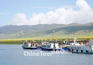 Qinghai Lake, Xining
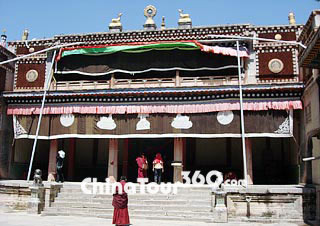 Ta'er Monastery
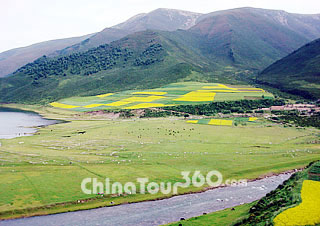 Beautiful Scenery in Qinghai
'Don't you see that the Yellow River spilling out of the Heavens, Tangling strands and rolling all the way thrust into the sea?' The 'Heavens' mentioned in this poem by the famous Tang poet Li Bai just specifies the beautiful Qinghai Province.
Qinghai Province is called Qing for short. It got its name from its Qinghai Lake, the largest inland saltwater lake in the country. The province lies on the northeastern part of the Qinghai-Tibet Plateau - 'Roof of the World' in west China, bordering Gansu and Sichuan provinces, Xinjiang Uygur Autonomous Region and Tibet Autonomous Region. Most areas of the province are mountain lands of high elevation. The average elevation is more than 3,000 meters (9,843 feet) above sea level, while 54 percent of the area is between 4,000 (13,123 feet) and 5,000 meters (16,404 feet). The total land area of the province is 720,000 square kilometers (277,994 square miles).
The province is naturally divided into two parts by Riyue Mountain: pastoral area in the west and agricultural area in the east. The Qaidam Basin in the northwest is a large, relatively unoccupied area. Most of the population resides in the river valleys in the east. By area, it is the largest province in China - excluding the autonomous regions of Xinjiang, Tibet, and Inner Mongolia, which are technically not provinces.
Qinghai has a plateau continental climate thanks to its elevation, topography, latitude and atmospheric circulation. The greater part of it is dry and cold and with long winters, short summers, frequent winds, little rainfall, long hours of sunshine and great differences in temperature between day and night. Its average temperature is approximately -5 to 8 Celsius (23 to 46.4 Fahrenheit), with January temperatures ranging from -18.2 to -7 Celsius (-0.8 to 19.4 Fahrenheit) and July temperatures ranging from 5 to 21 Celsius (41 to 69.8 Fahrenheit). It is also prone to heavy winds as well as sandstorms from February to April.
Qinghai is abundant in river branches, streams, lakes as well as wildlife resources. The beautiful glaciers and rolling lofty mountains offer the ideal places for mountain-climbing and scientific investigations. Qinghai Lake is a national major famous scenic area. There stands a Bird Island in the northwestern part of the lake; where over 100,000 various birds are dwelling from May to autumn every year, presenting a splendid sight.
The Qaidam Basin, once been prosperous as the ancient Silk Road stretching across much of its length, is an ideal place for expedition. You can explore the End of the World, mystic Lost City and discover the beauty of dazzling salt lakes.